Apps for Magic Leap 2
Find the Magic Leap 2 app you need according to your industry, use case, and Independent Software Vendor (ISV) preferences.
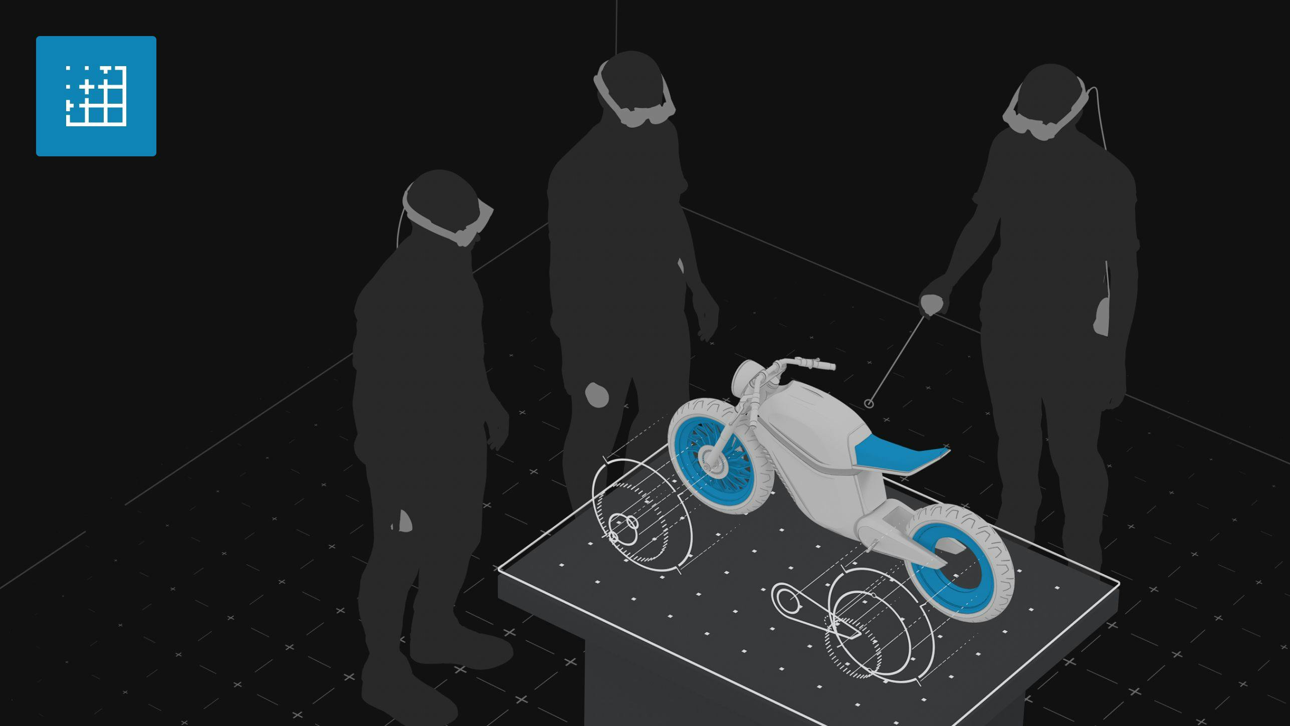
Apps by Magic Leap
Included for download with every Magic Leap 2 device, Magic Leap apps are fundamental, broad-use augmented reality apps that provide customers with out of the box utility and demonstrate AR’s effectiveness within their industry.
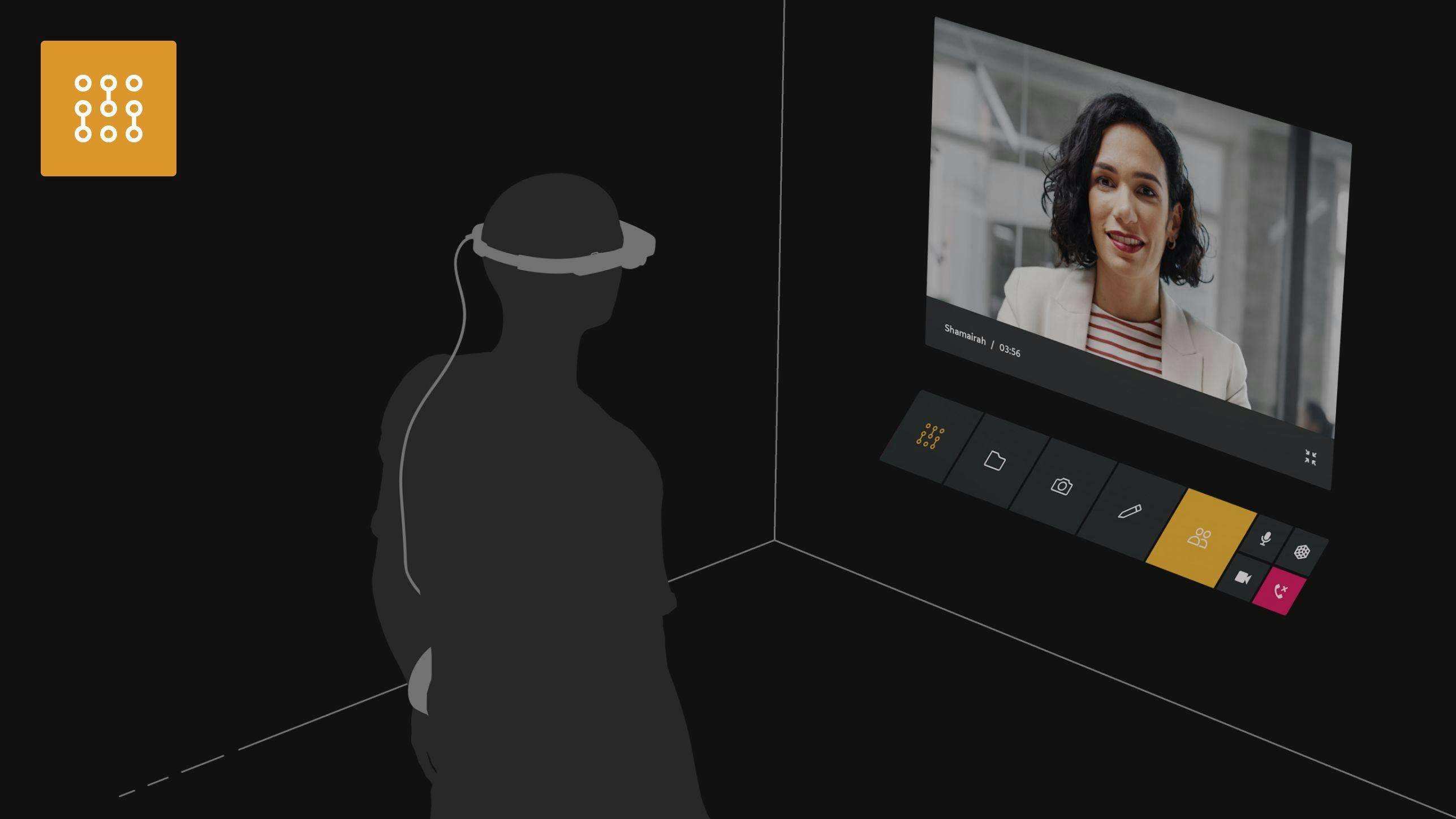
Magic Leap Assist
Magic Leap Assist remotely connects organizations’ employees to their experts no matter where they are, and can be used to improve any remote support scenario, from diagnostic services to training and everything in between.
Magic Leap Workshop
Magic Leap Workshop is transforming the way organizations collaborate through AR. This versatile tool is perfect for a wide range of group activities, from brainstorming and prototyping to delivering impactful presentations. By integrating Workshop, teams can experience a new dimension of collaboration, enhancing efficiency and creativity in every aspect of their group interactions.
Apps for Magic Leap 2
Changing filters will update the displayed items in the grid.
82 apps found
Agora Labs
Agora Labs
The leading Real-Time Engagement (RTE) platform, helping developers deliver rich in-app experiences—including embedded voice and video chat, real-time recording, interactive live streaming, and real-time messaging.
Industries: AEC, Healthcare, Manufacturing, Other
Use cases: Collaboration, Remote Assistance, Simulation/visualization, Training
Akular
AKULAR
Mitigate the challenges of traditional construction methods. Streamline construction from initial design and planning, through construction and inspection to monitoring and managing building operations. Features precise spatial mapping for accurate integration of 3D BIM models and digital twins. Additional industries served: Real Estate
Industries: AEC, Other
Use cases: Simulation/visualization
Anarky Labs
AirHUD
The world's first real heads-up display (HUD) solution for drone pilots, ensuring you are always in complete situational control. Use Magic Leap AR as a training environment with a simulated drone, with zero chance of drone damage and no weather restrictions. Industries served: Agriculture, Oil and Gas, Film, Forestry
Industries: Other
Use cases: Simulation/visualization
AR Genie
Workflow Instructions
Provides real time visual guidance that allows experts to optimize workflow processes by overlaying digital step-by-step instructions and 3D models onto their field of vision. Streamlines complex tasks, reduces errors, and enhances productivity across various industries.
Industries: AEC, Healthcare, Manufacturing, Other
Use cases: Collaboration, Remote Assistance, Simulation/visualization, Training
AR Genie
Remote Assistance
Provides real-time visual support to users, allowing experts to guide and collaborate with others remotely by placing annotations on the real world environment. Enhances problem-solving, reduces downtime, and improves efficiency across various industries, making complex tasks more accessible.
Industries: AEC, Healthcare, Manufacturing, Other
Use cases: Collaboration, Remote Assistance, Simulation/visualization, Training
Arbor XR
Arbor XR
Remotely manage AR and VR devices, deploy content, and control what users can see and do in the Magic Leap headset. Additional industries served: Retail, Public Sector
Industries: AEC, Healthcare, Manufacturing, Other
Use cases: Collaboration, Remote Assistance, Simulation/visualization, Training
ARCortex
ARCortex
ARCortex and Magic Leap partner to bring Augmented Reality to Defense and Enterprise clients. We deliver ready to use applications that help business boost productivity and access data on demand. Industries served: Public Sector
Industries: Other
Use cases: Collaboration, Remote Assistance, Simulation/visualization, Training
Argyle
Argyle
Converts your BIM into aligned, interactive holograms to supplement layout and QA of building projects. Patented alignment technology is responsive to changing site conditions. One-click BIM updates for real time site visualization.
Industries: AEC
Use cases: Simulation/visualization
Arvizio
AR Instructor
Cross-OS AR guided work instruction solution with no-code authoring, integrated 3D models, documents, videos for operations, maintenance and training scenarios. Connect with a remote expert with see-what-I-see video for additional guidance and work validation. Additional industries served: Telecomm, Data Centers, Public Sector
Industries: Healthcare, Other
Use cases: Remote Assistance, Training
Avrio
De-escalation
Uses artificial intelligence to power realistic, nuanced training encounters with digital characters. Can create muscle memory during active shooter scenarios and calls for service, honing officers’ skills for unpredictable, real-world challenges. Industries served: Public Sector
Industries: Other
Use cases: Simulation/visualization, Training
Avrio
Stratscape Tabletop Exercise
Provides first responders with realistic, dynamic, customizable command and control training. Participants engage in immersive AR scenarios to visualize targeted hazards and practice drills. Enables participants to exercise resource deployment and strategic responses in real time. Industries served: Public Sector
Industries: Other
Use cases: Simulation/visualization, Training
Avrio
Watchword Active Shooter
Avrio Watchword enables immersive, augmented reality (AR) training for first responders and emergency managers across a range of high-risk scenarios, tapping Magic Leap's powerful AR platform for realistic and effective experiences in real-world spaces. Industries served: Public Sector
Industries: Other
Use cases: Simulation/visualization, Training
Beame
Beame
Interact with lifelike avatars of other participants, and explore and manipulate 2D and 3D content in ways that are impossible in the real world, unlocking new insights and closing communication gaps. The world's most advanced collaboration platform. Additional industries served: Real Estate, Aerospace, Public Sector
Industries: Healthcare, Manufacturing, Other
Use cases: Collaboration, Simulation/visualization
BlippAR
Blippbuilder
Easy-to-use, yet powerful, no-code 'AR for all' cross-platform creation tool that empowers creators of any level to build once and publish everywhere. Industries served: Retail, eCommerce, Marketing and Advertising, Tourism, Education
Industries: Other
Use cases: Simulation/visualization
Box Bear
HoloPresenter
Allows content to be constructed into a presentation and slides. Headsets can be dynamically assigned as presenter or viewer, and presenters can control content on viewers' headsets via an iPad for nonlinear presentations, or with an iPad or headset controller for linear presentations. Additional industries served: Retail, Public Sector
Industries: AEC, Healthcare, Manufacturing, Other
Use cases: Simulation/visualization
Box Bear
VolCap
A volumetric filming rig that captures a hologram of subjects, ready for viewing in Magic Leap headsets. Integration with Unreal Engine, Unity, JavaScript, 8th Wall, Blender and custom applications, either as live or pre-recorded content. Industries served: Retail
Industries: Other
Use cases: Collaboration, Simulation/visualization, Training
Brainlab
Mixed Reality Viewer
Provides multi-user visualization of 3D diagnostics, allowing more insightful collaboration, presurgical planning, teaching, and communication. Specialists can collaborate on cases with a greater degree of specificity and nuance, planning and rehearsing surgeries before a single incision is made.
Industries: Healthcare
Use cases: Collaboration, Simulation/visualization, Training
Cisco
Webex Hologram
An immersive 3D meetings solution, bringing real-time, photorealistic holographic experiences to Webex. Allows meeting participants from around the world to collaborate in inclusive and engaging ways by projecting the presenter and their content into the viewer's physical space. Additional industries served: Retail, Public Sector
Industries: AEC, Healthcare, Manufacturing, Other
Use cases: Collaboration, Simulation/visualization
Draw & Code
Draw & Code
Draw & Code's team of AR designers and developers deliver high-profile Magic Leap experiences for global organizations. Additional industries served: Retail, Public Sector
Industries: AEC, Healthcare, Manufacturing, Other
Use cases: Collaboration, Remote Assistance, Simulation/visualization, Training
EnterAR
EnterAR
Helps visualize upcoming construction for new facilities by utilizing BIM overlays with actual structures. For facility managers, EnterAR enables IoT/BMS data view and work orders creation for the assets and building systems. Additional industries served: Facilities Management
Industries: AEC, Manufacturing, Other
Use cases: Simulation/visualization
EolianVR
ARTAK
Designed to provide enhanced situational awareness and 3D mission planning capabilities. Prototyped under an Other Transaction (OT) Agreement between Eolian and USSOCOM, it leverages a system optimized for massive multiuser and edge-based augmented reality, virtual reality, and mobile devices. Additional industries served: Public Sector
Industries: Healthcare, Other
Use cases: Training
FifthIngenium
ART
Offers exhibition organizers the capability to create engaging immersive experiences for visitors by showing 2D and 3D interactive content in real or virtual environments, created with a no-code editor. It also offers interactive virtual guides to enhance tours, museums, and more through XR. Additional industries served: Retail, Design, Entertainment
Industries: Other
Use cases: Simulation/visualization
FifthIngenium
BraIND 4.0
An XR and AI modular platform that covers the most important aspects of today's smart factories: increasing productivity, reducing variability and mistakes, cutting machinery downtime and repair time while improving workplace safety by bringing all the relevant information to the worker in XR. Additional industries served: Automotive, Oil and Gas, Aerospace, Utilities, Public Sector
Industries: AEC, Manufacturing, Other
Use cases: Collaboration, Remote Assistance, Simulation/visualization, Training
FifthIngenium
HoloDentist
HoloDentist allows doctors to recreate the Virtual Patient by combining all the 3D data in a fully 3D environment: it is designed for doctor-patient communication, team collaboration, immersive training and pre-surgery preparation.
Industries: Healthcare
Use cases: Collaboration, Simulation/visualization
FifthIngenium
TINALP
Creates a realistic immersive learning experience, enabling new ways of training through mobile cloud classroom and virtual presence.Teachers can retrieve real time information in order to shape training for each student's specific needs and capabilities.
Industries: AEC, Healthcare
Use cases: Collaboration, Simulation/visualization
FifthIngenium
XRV
A highly customizable XR app suited for demoing the technology and features of Magic Leap 2, with real-time interaction, dynamic content loading, multi-user access and AR/VR support platform. Thanks to a no-code content editor, XRV allows consulting companies to easily showcase the power of XR. Additional industries served: Retail
Industries: AEC, Other
Use cases: Collaboration, Simulation/visualization, Training
Flow Immersive
Flow Immersive
An SaaS platform to build and experience interactive 3D data visualizations on the web and in augmented reality that can be extended with conversational AI. Use cases include stakeholder alignment around managing risk—environmental risks, project management risks, financial risks, and more. Additional industries served: Public Sector, Telco, Finance, Oil and Gas, Utilities, Education
Industries: Healthcare, Other
Use cases: Simulation/visualization, Training
Forma Vision
Forma Studio
Communicate and collaborate naturally as if in the same room using real time holograms. Designed for business professionals who would prefer to meet with others as their authentic selves in the metaverse, as opposed to an avatar persona. Additional industries served: Education, Telco, Entertainment
Industries: Healthcare, Other
Use cases: Collaboration, Training
Fracture Reality
JoinXR Enterprise
A platform for high-performance visualization and collaboration in an immersive virtual space. Users can structure their own 3D content for collaboration, training and simulation in an easy-to-access multi-user immersive space, enhanced with photoreal avatars and spatial audio. Additional industries served: Retail, Public Sector, Automotive, IT Software, Telco, Aerospace, Finance, Oil and Gas, Utilities, Education, Real Estate
Industries: AEC, Healthcare, Manufacturing, Other
Use cases: Collaboration, Simulation/visualization, Training
Fracture Reality
JoinXR Simulations
A suite of real-world clinical experiences with digital avatars in AR/VR environments. Each simulation enables a powerful learning experience by providing realistic communication and natural engagement in a high-fidelity clinical setting, making each interaction truly immersive. Additional industries served: Retail, Public Sector, Automotive, IT Software, Telco, Aerospace, Finance, Oil and Gas, Utilities, Education, Real Estate
Industries: Healthcare
Use cases: Collaboration, Simulation/visualization, Training
Frontline.io
Frontline
Enhance your teams' capabilities and save time and money with virtual 3D interactive training, augmented reality remote support and real time analytics—all in one platform.
Industries: AEC, Healthcare, Manufacturing
Use cases: Remote Assistance, Training
GeniusX
GeniusX
GeniusX provides experiential, personalized, wellness-focused, AI-driven accelerated learning. Through a model of practice, score, and iterate (PSI) we use the latest in biometrics, AI, and spatial computing to deliver a hyper-accelerated form of education that builds lasting neuroplasticity and soft skills improvement in the process."
Industries: AEC, Healthcare, Manufacturing
Use cases: Simulation/visualization, Training
Geopogo Inc.
Geopogo
With Geopogo AR models, entire design and construction teams can fully experience projects before they are built, clearly identify design issues, and complete the design and construction process faster, at a lower cost, and with higher quality.
Industries: AEC
Use cases: Simulation/visualization
Hevolus
H-COLLABORATION
H-Collaboration increases training engagement and effectiveness. It improves learning outcomes by offering practical, interactive, and collaborative training experiences. It promotes accessibility allowing employees to participate from everywhere via any device (headset, mobile phone or tablet) with just a QR code. Additional industries served: Design, Automotive, Entertainment, IT Software, Teco, Oil & Gas, Reseller, Utilities, Education, Real Estate
Industries: AEC, Healthcare, Manufacturing, Other
Use cases: Collaboration, Remote Assistance, Simulation/visualization, Training
Hevolus
H-FAIR
H-Fair allows sales assistants to bring digital twins to events and fairs. H-Fair allows you to place 3D digital twins everywhere, from a trade fair booth to an exhibition space, without worrying about size or weight. Additional industries served: Design, Automotive, Entertainment, IT Software, Teco, Oil & Gas, Reseller, Utilities, Education, Real Estate
Industries: AEC, Healthcare, Manufacturing, Other
Use cases: Collaboration, Remote Assistance, Simulation/visualization, Training
Hevolus
H-MAINTENANCE
H-Maintenance enables real-time maintenance interventions and helps companies and operators to collaborate remotely and manage any type of issue. H-Maintenance is the platform for remote maintenance that enables real time intervention—drastically reducing time, costs and errors. Additional industries served: Design, Automotive, Entertainment, IT Software, Teco, Oil & Gas, Reseller, Utilities, Education, Real Estate
Industries: AEC, Healthcare, Manufacturing, Other
Use cases: Collaboration, Remote Assistance, Simulation/visualization, Training
Hevolus
H-ONBOARDING
H-Onboarding creates an interactive, immersive and simple onboarding experience for your employees. It facilitates and speeds up employees’ onboarding process and allows to create a virtual version of the company. Additional industries served: Design, Automotive, Entertainment, IT Software, Teco, Oil & Gas, Reseller, Utilities, Education, Real Estate
Industries: AEC, Healthcare, Manufacturing, Other
Use cases: Collaboration, Remote Assistance, Simulation/visualization, Training
Hevolus
H-PROTOTYPE
H-Prototype increases efficiency, collaboration and speed at each level of physical production. It facilitates interactively and realistically attaching virtual prototypes to physical objects with 1-millimeter accuracy, saving design time and costs. Additional industries served: Design, Automotive, Entertainment, IT Software, Teco, Oil & Gas, Reseller, Utilities, Education, Real Estate
Industries: AEC, Healthcare, Manufacturing, Other
Use cases: Collaboration, Remote Assistance, Simulation/visualization, Training
Hevolus
H-SHARE
With H-Share, you can generate QR Codes to share content with anyone via WebXR, through any device. H-Share creates a common content repository. Additional industries served: Design, Automotive, Entertainment, IT Software, Teco, Oil & Gas, Reseller, Utilities, Education, Real Estate
Industries: AEC, Healthcare, Manufacturing, Other
Use cases: Collaboration, Remote Assistance, Simulation/visualization, Training
Hevolus
H-STORE
H-Store provides an engaging phygital customer experience, allowing retailers to present products and their color/texture/size variants to customers in any location. H-Store combines the holographic shopping experience with the physical one, offering engaging phygital customer experiences. Additional industries served: Design, Automotive, Entertainment, IT Software, Teco, Oil & Gas, Reseller, Utilities, Education, Real Estate
Industries: AEC, Healthcare, Manufacturing, Other
Use cases: Collaboration, Remote Assistance, Simulation/visualization, Training
Hevolus
HVERSE
The world’s first XR an Gen AI platform that offers a vertical product for each business process and educational scenario through a low-poly/low-code approach. Additional industries served: Retail, Automotive, Entertainment, IT Software, Telco, Oil and Gas, Utilities, Education, Real Estate
Industries: AEC, Healthcare, Manufacturing, Other
Use cases: Collaboration, Remote Assistance, Simulation/visualization, Training
Hololight
Space
A powerful XR software for visualizing, collaborating and interacting with 3D content. Users can visualize and work with their own 3D CAD files to review designs, plan a factory layout, perform quality assurance, or check assembly processes. Additional industries served: Retail, Public Sector, Automotive, IT Software, Telco, Aerospace, Oil and Gas, Utilities, Education
Industries: AEC, Healthcare, Manufacturing, Other
Use cases: Collaboration, Remote Assistance, Simulation/visualization, Training
Hololight
Stream
By implementing Hololight Stream in any type of XR application, the rendering of XR applications is offloaded from the XR device to more powerful servers or the cloud. The solution enables real-time streaming of high-quality XR content from the server to the XR device. Additional industries served: Retail, Public Sector
Industries: AEC, Healthcare, Manufacturing, Other
Use cases: Collaboration, Remote Assistance, Simulation/visualization, Training
Immersal
Immersal
Immersal’s technology allows users to build spatial maps of real-world locations and use those maps for visual positioning in AR and MR applications. Digital content can be precisely overlaid in AR experiences in diverse environments, revolutionizing user interaction with their surroundings. Industries served: Aerospace, Finance, Hospitals/Physician Clinics, Utilities
Industries: Other
Use cases: Simulation/visualization
Insight Enterprises
Insight Enterprises
Magic Leap and Insight Enterprises, Inc.help organizations accelerate their digital journey to modernize their business and maximize the value of technology. Insight enables secure, end-to-end transformation of their comprehensive portfolio of solutions. Additional industries served: Retail, Public Sector
Industries: AEC, Healthcare, Manufacturing, Other
Use cases: Collaboration, Remote Assistance, Simulation/visualization, Training
Insight Global
Insight Global
Insight Global creates simple end-to-end solutions for big, complicated, often daunting projects. They partner with companies like Magic Leap to provide custom engineering services to operational support services. Additional industries served: Retail, Public Sector
Industries: AEC, Healthcare, Manufacturing, Other
Use cases: Collaboration, Remote Assistance, Simulation/visualization, Training
iQ3Connect
iQ3Connect
iQ3Connect provides an easily scalable, end-to-end AR/VR solution that allows users to take CAD, point cloud scans, PDF, videos, and other assets and collaborate quickly and easily in a Zoom-like secure environment. There are no software installations or individual licenses, greatly simplifying enterprise deployment. Easy-to-use no-code tools allow anyone to build, author, and package content for a wide variety of applications like design review prototyping, manufacturing simulations, training, maintenance instructions, and more.
Industries: AEC, Healthcare, Manufacturing
Use cases: Collaboration, Remote Assistance, Simulation/visualization, Training
Ivanti
Ivanti Neurons
Allows organizations to easily manage the end-to-end lifecycle of all endpoints and enables secure access to their business data and apps on any endpoint, including XR devices used by their employees, contractors, and frontline workers. Additional industries served: Public Sector
Industries: AEC, Manufacturing, Other
Use cases: Remote Assistance, Training
Kognitiv Spark
RemoteSpark
Combines the physical and digital worlds by creating a hands-free, supportive environment for workers to instantly access 2D and 3D holographic assets to support task completion, operational efficiency, training, and digital transformation efforts in an independent and autonomous manner.
Industries: AEC, Manufacturing
Use cases: Remote Assistance, Training
lifecache
lifecache
Simplifies the publishing of real-time immersive content for users to consume in AR, provides a suite of tools to manage and optimize content, and aggregates unique data & analytics to guide decision making on the end-user AR experience. Industries served: Public Sector, Travel and Tourism, Entertainment, Transportation
Industries: Other
Use cases: Collaboration, Simulation/visualization
MakeSEA
Catapult
makeSEA is a content management system that enables sharing of self-produced spatial experiences, features enterprise security and co-presence out-of-the-box, and serves as an enabling foundation and rapid prototyping tool for custom apps. makeSEA+Catapult makes Magic Leap 2 instantly useful for any discipline as a better means of explaining, demonstrating, and influencing. Additional industries served: Retail, Education, E-commerce, Entertainment, Marketing
Industries: AEC, Manufacturing, Other
Use cases: Collaboration, Simulation/visualization
ManageEngine
Endpoint Central
Empowers your IT to manage a broad spectrum of devices and OSs in your enterprise, including XR devices. Onboard, customize, maintain and troubleshoot devices and apps anywhere, anytime. Automate and customize app updates and restrict access to approved applications and hardware functionalities. Additional industries served: Public Sector, Retail
Industries: AEC, Healthcare, Manufacturing, Other
Use cases: Remote Assistance, Training
ManageXR
ManageXR
Set up and provision hundreds of devices quickly with our Device Setup Tool. Distribute apps, videos, webXR, files, and firmware updates remotely. Customize your home screen and use Kiosk Mode to control the user experience. Additional industries served: Public Sector, Retail
Industries: AEC, Healthcare, Manufacturing, Other
Use cases: Collaboration, Remote Assistance, Simulation/visualization, Training
Nomtek
B-all One
Nomtek and Magic Leap partnered to create a single-player indoor squash game that employs complex technology that probes the user’s environment. Industries served: Retail, Gaming
Industries: Other
Use cases: Simulation/visualization
NVIDIA
Holoscan
Delivers the full-stack infrastructure needed for scalable, software-defined, real-time processing of streaming data at the edge—so developers can build devices and deploy AI applications directly into clinical settings.
Industries: Healthcare
Use cases: Collaboration, Simulation/visualization
NVIDIA
Omniverse
NVIDIA Omniverse™ is a computing platform that enables individuals and teams to develop Universal Scene Description (OpenUSD)-based 3D workflows and applications.
Industries: AEC, Manufacturing
Use cases: Simulation/visualization
Overlay
FigminXR
Create, experience and collaborate with powerful built-in tools, including 3D drawing powered by Tilt Brush, GIPHY, and SketchFab, YouTube and Reddit integration, and physics and text editors. Augment a physical room, create physics experiences, design captivating marketing content, and more. Additional industries served: Retail, Public Sector
Industries: AEC, Healthcare, Manufacturing, Other
Use cases: Collaboration, Simulation/visualization
PTC
Vuforia Engine
Enables creating augmented reality applications both natively and on development platforms like Unity. Customers can not only build AR solutions which can boost workforce efficiency and lower costs across the factory floor, but enhance consumer facing applications as well.
Industries: AEC, Manufacturing
Use cases: Collaboration, Simulation/visualization, Training
Seisan Consulting
Seisan Consulting
Seisan is a technology consultancy that understands your business problems and objectives and creates the ideal customized solution to produce efficiencies, increase productivity, and allow you to focus more time on high-value work. Industries served: Retail, Finance, Restaurants, Automotive, Consumer
Industries: Other
Use cases: Collaboration, Remote Assistance, Simulation/visualization, Training
SentiAR
SentiAR
Holographic AR technology that provides physicians with a single source of truth during interventional procedures – giving them a real-time, interactive, 360-degree view of the treatment they’re delivering.
Industries: Healthcare
Use cases: Simulation/visualization
Shape Immersive
Shape Immersive
Shape Immersive and Magic Leap partner to help brands define their 3D technology roadmaps and build award-winning AR apps. Shape's service pillars are 3D production, 3D data, metaverse production development, and enterprise software integration. Industries served: Retail
Industries: Other
Use cases: Simulation/visualization
Siemens
Ecodomus
Stores and visualizes facility information in 2D, 3D, AR, and VR. The first BIM-based data management solution connected to CMMS, CAFM, BMS, GIS, ERP, simulation packages, and more, enabling the full Digital Twin of a facility or a whole campus.
Industries: AEC, Manufacturing
Use cases: Simulation/visualization
SimplyVideo
SimplyVideo
An XR platform for out-of-the-box assisted and mixed reality solutions for remote collaboration, remote support and 3D visualization use cases. Integrates natively with Microsoft Teams or Google Meet to ease adoption and visibility, and can be deployed into self-hosted or private cloud environments. Additional industries served: Retail, Travel, Energy, Media, Finance
Industries: AEC, Healthcare, Manufacturing, Other
Use cases: Collaboration, Remote Assistance, Simulation/visualization, Training
SimplyVideo
SimplyVideo SDK
Provides Magic Leap developers with native integration with Microsoft Teams, Google Meet, and video conferencing hardware, as well as private cloud and on-premise deployment capabilities through a standalone application and SDK. Additional industries served: Public Sector, Retail, Automotive, Entertainment, Telco, Business Services, Aerospace, Finance, Hospitals and Physician Clinics, IT and Services, Oil and gas, Utilities, Education, Real estate
Industries: AEC, Healthcare, Manufacturing, Other
Use cases: Collaboration, Remote Assistance, Simulation/visualization, Training
simXAR
simXAR
simXAR's solution, utilizing proprietary mixed reality technology enables immersive, real-time 3D modeling for both surgical training and detailed anatomy education. It allows medical professionals to practice and visualize complex surgeries and study human anatomy with unparalleled clarity and interactivity. Enhancing learning outcomes, surgical precision, and anatomical understanding, simXAR sets a new benchmark in medical education and operational planning, making it a comprehensive educational tool in the medical field. Additional industries served: Education
Industries: Healthcare, Other
Use cases: Collaboration, Simulation/visualization, Training
Slalom
Slalom
Slalom and Magic Leap partner to deliver practical, end-to-end solutions that drive meaningful impact. Custom recommendations and development keep our joint customers ahead with cutting edge technology. Additional industries served: Retail, Public Sector
Industries: AEC, Healthcare, Manufacturing, Other
Use cases: Collaboration, Remote Assistance, Simulation/visualization, Training
SoftServe
SoftServe
Softserve and Magic Leap partner in pursuit of excellence and the thrill of competition. Our AR solutions enable all-new uses cases to ensure business continuity, improve availability and optimize efficiency—giving you a competitive edge. Additional industries served: Retail, Public Sector
Industries: AEC, Healthcare, Manufacturing, Other
Use cases: Collaboration, Remote Assistance, Simulation/visualization, Training
Sphere
Sphere
Sphere’s spatial collaboration tool is embraced by Fortune-500 companies worldwide. Its turnkey XR solution revolutionizes communication and complex problem-solving, leading to cost reductions and heightened productivity. Covering all critical use-cases in one unified application, Sphere enables colleagues to supercharge meetings, sales teams to sell more, employees to connect with remote experts, and frontline staff to enhance accuracy. Rather than replacing existing workflows, it easily integrates secure, purpose-built augmented reality software into daily business processes. Additional industries served: Retail, Public Sector
Industries: Healthcare, Manufacturing, Other
Use cases: Collaboration, Remote Assistance, Training
Svarmony
Svarmony
Svarmony and Magic Leap partner to bring customized AR products and solutions for sustainable, future-forward brands. Additional industries served: Public Sector, Retail, Automotive, Entertainment, Telco, Business Services, Aerospace, Hospitals and Physician Clinics, Oil and Gas, Reseller, Education
Industries: Manufacturing, Other
Use cases: Simulation/visualization, Training
Svarmony
Visualizer
The AR visualizer by svarmony optimizes processes and creates target-group-specific and emotional customer experiences that will be remembered. Even complicated application possibilities can be vividly explained with this ingenious solution and, among other things, offer valuable help in the purchase decision. Additional industries served: Public Sector, Retail, Automotive, Entertainment, Telco, Business Services, Aerospace, Hospitals and Physician Clinics, Oil and Gas, Reseller, Education
Industries: Manufacturing, Other
Use cases: Simulation/visualization, Training
Synergiz
Synergiz Harbor
An intuitive and user-friendly mixed reality collaboration software solution designed for enterprise use. It serves as an enterprise-grade platform, enabling to effortlessly manage, secure, and deploy assets at large scale, and deliver rich, interactive and efficient business experiences. Additional industries served: Retail, Public Sector, Design, Automotive, Telco, Aerospace, Oil and Gas, Utilities, Education
Industries: AEC, Healthcare, Manufacturing, Other
Use cases: Collaboration, Simulation/visualization, Training
Taqtile
Manifest
Gives workers instant access to step-by-step guidance from your most experienced technicians and trainers anywhere, anytime. Additional industries served: Public Sector
Industries: Manufacturing, Other
Use cases: Remote Assistance, Training
vGIS AR
vGIS AR
A 3D digital twin and geospatial hub powered by AI and AR, purpose-built for infrastructure projects to create a common data environment (CDE). It brings all spatial data, including BIM, GIS, point clouds, sheets and issue reports into a unified, always up-to-date 3D view of the construction site. Additional industries served: Oil and Gas, Utilities
Industries: AEC, Other
Use cases: Collaboration, Remote Assistance, Simulation/visualization, Training
View AR
Service AR
An all-in-one industrial AR solution to enhance efficiency and quality of maintenance and operations processes and workers safety. The user's field of view is augmented with information such as indoor navigation, visual indications, step-by-step instructions, and remote assistance. Additional industries served: Retail, Public Sector
Industries: AEC, Healthcare, Manufacturing, Other
Use cases: Collaboration, Remote Assistance, Simulation/visualization, Training
VIM AEC
VIM AEC
Decouples and translates large, complex closed source BIM projects into real-time open VIMs intuitively. Users get a significant business intelligence boost with complete data and beautiful geometry at scale as they reduce project costs and delivery schedules, and increase profitability. Additional industries served: Retail, Public Sector
Industries: AEC, Healthcare, Manufacturing, Other
Use cases: Collaboration, Remote Assistance, Simulation/visualization, Training
Visometry
VisionLib
VisionLib is an augmented reality tracking library created by Visometry. It enables you to create augmented reality applications at industrial scale using computer vision tracking technologies. Whatever tracking technique you employ, VisionLib exposes this information for you to use in your development environment, allowing you to precisely align your content to real objects. Additional industries served: Retail
Industries: AEC, Healthcare, Manufacturing, Other
Use cases: Simulation/visualization
Visoric GmbH
XR Stager
Allows users to manage digital twins and create animations, simulations, and individual product configurations, all in a cloud-based system. Leveraging AI, the XR Stager streamlines material and design reviews, all viewable within the Magic Leap 2 headset. Additional industries served: Public Sector, IT, Education, Real Estate, Aerospace
Industries: Manufacturing, Other
Use cases: Simulation/visualization
VISR Stage
VISR Stage
Experience augmented worlds and engage with customizable avatars to collaborate in real-time, transforming the way you do business. With self-authored digital experiences that's as easy to use as Powerpoint, Stage empowers your team to communicate effectively and efficiently, creating value for your customers like never before. Additional industries served: Education, Energy
Industries: Manufacturing, Other
Use cases: Collaboration, Simulation/visualization
VMWare
eXtended Reality
Unify endpoint management for enterprise devices, including your XR devices. Enroll XR devices, configure device policies, deliver a custom app library, deploy apps and content, remotely troubleshoot, securely wipe devices, view analytics, and more. Additional industries served: Retail, Public Sector
Industries: AEC, Healthcare, Manufacturing, Other
Use cases: Collaboration, Remote Assistance, Simulation/visualization, Training
VNTANA
VNTANA
Patented optimization algorithms that automatically reduce file size and polygon count without losing detail. Instantly deploy 3D files from Solidworks, AutoCAD, Inventor, Revit, Ansys and many more design programs into any Magic Leap experience. Additional industries served: Public Sector, Automotive, Entertainment, Telco, Aerospace, Hospitals and Physician Clinics, Oil and Gas, Software, Utilities, Education, Real Estate, Design
Industries: AEC, Healthcare, Manufacturing, Other
Use cases: Collaboration, Remote Assistance, Simulation/visualization, Training
Warpin Reality
Warpin Reality
Magic Leap and Warpin Reality design immersive technology solutions that bring businesses to the forefront of digital innovation. Magic Leap relies on Warpin Reality's end-to-end capabilities in-house from strategy/concept to final delivery/distribution. Additional industries served: Retail, Public Sector
Industries: AEC, Healthcare, Manufacturing, Other
Use cases: Collaboration, Remote Assistance, Simulation/visualization, Training
XR Masters
XR Masters
Publish no code content on custom layers on the real world metaverse. Platform works with multiple VPS providers including Google and is compliant with geopose standards of OGC/OARC. Additional industries served: Retail, Public Sector
Industries: AEC, Healthcare, Manufacturing, Other
Use cases: Collaboration, Remote Assistance, Simulation/visualization, Training
Contact sales to learn how AR can improve the way you work
Magic Leap 2 is transforming industry standards for productivity and innovation. Let's talk about what it can do for your business.
This site is protected by reCAPTCHA and the Google Privacy Policy and Terms of Service apply.